Satellite
Area Layout
General
locations and Function
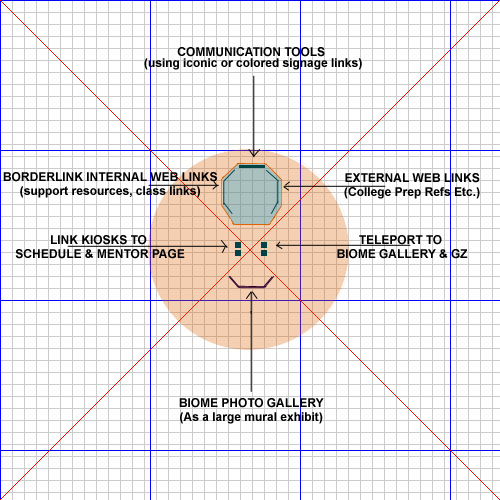
This
layout below shows the general layout for architecture, outside kiosks and gallery.
The arrows point to what type of materials will reside in which places from
a function point of view. The landing point (center of red crossed lines) assumes
that user lands facing the building which lies approximately 16 meters away
(Zg, you will need to test whether this is too close or not). The teleports
on right of landing point take user either back to ground zero or to the biome
gallery which is set off from landing point. To the left of landing point, the
user will always find links to the schedule and session information links. Internal
web links are of three general types: Links to tools, links to Borderlink pages
and links to external web-based resources so users will always know where to
find what type of resources. They can be displayed in a combination of kiosks/objects
and wall pics. We should continue discussing an iconic way of representing standard
links such as tools.
|
|
|
To
Other Area Maps 1
| 2 | 3 | 4
| 5 | 6 | 7
| 8 | 9 |
LinkWorld Working Site by Bonnie DeVarco 2000